Wildfire near Bastrop State Park triggers evacuations as Central Texas faces elevated fire weather conditions
Evacuations ordered as fire activity rises near Bastrop State Park
A wildfire burning in the Bastrop State Park area has prompted evacuations in parts of Bastrop County, as fire agencies respond under heightened wildfire danger conditions that have affected wide stretches of Texas in recent months.
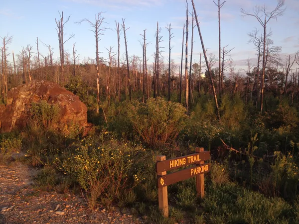
The incident is the latest in a pattern of fast-moving, wind-driven fires that can develop quickly in the Lost Pines region—an ecologically distinct pine forest belt east of Austin that includes Bastrop and Buescher state parks and surrounding communities.
What is known about the current response
Authorities ordered residents to leave designated areas near the park as crews worked to contain the fire. In similar recent incidents in the same corridor between Bastrop State Park and Buescher State Park, evacuations have focused on neighborhoods and road segments near Park Road 1C and adjoining local roads, with closures used to keep the public out of active operations and to reduce risk from shifting fire behavior.
Texas has entered another period of elevated wildfire activity. State officials renewed a statewide disaster declaration for fire weather conditions on March 9, 2026, listing Bastrop County among the affected jurisdictions. That declaration reflects ongoing concerns about the combination of dry fuels, low humidity, and gusty winds—conditions that can turn small ignitions into larger incidents within hours.
Why Bastrop’s parklands remain vulnerable
Bastrop State Park sits within the Lost Pines, a stand of loblolly pine separated from East Texas’ larger pine forests. The area’s fuel mix—grasses, brush, and pine needle litter—can support rapid fire spread during dry and windy weather, particularly along the wildland-urban interface where neighborhoods border park and timberland.
The region’s vulnerability is shaped by its fire history. In September 2011, the Bastrop County Complex Fire burned across the Lost Pines and heavily impacted Bastrop State Park, with the park reporting that fire affected about 96% of its acreage. Recovery has been ongoing for years, including forest restoration and changes in land management strategies designed to reduce hazardous fuel buildup.
What residents should monitor
During active wildfire incidents, official instructions can change quickly based on wind shifts and containment progress. Residents near Bastrop State Park typically need to track:
- Evacuation zones and re-entry guidance issued by local emergency management and law enforcement
- Road closures, especially connectors used to access homes and park areas
- Public shelter or reunification locations if displacement is required
- Air quality impacts from smoke, particularly for sensitive groups
In Central Texas, wildfire risk can escalate rapidly when dry fuels align with strong winds, making early evacuation compliance a key safety measure.
Context: a broader Texas wildfire season
Fire agencies across the state have reported unusually heavy winter and early-spring workload in 2026. With March historically one of Texas’ busiest months for dormant-season fires, the Bastrop-area evacuation underscores how quickly local incidents can develop even when the initial footprint is limited.
Officials have not consistently released a single, statewide incident narrative for every fire near Bastrop State Park, but the operational priorities remain the same: protect life, keep fire out of homes and critical infrastructure, and establish containment lines using ground crews and, when needed, heavy equipment and aviation resources.